Video Description
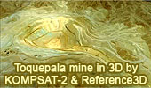
This 3D flyover was generated by combining a Reference3D digital elevation model and a 1-metre KOMPSAT-2 orthoimage of the Toquepala copper mine in Peru.
The resulting image gives a good idea of the scale of this vast open-cast mine, 2.5 km across and 700 m deep. The mine began operating in 1960. Spoil dumps of material mined from the pit are arranged in tiers on the arid slopes of the Andes in southern Peru. The mine is linked by rail to the port of Ilo on the Pacific coast.
A 3D and optical database integrated into a GIS helps to optimize management of industrial and mining facilities, as well as aiding risk prevention.
Satellite imagery is used by surface and underground mining operators for:
-Exploration: to identify minerals ahead of geophysical surveying
-Operations: to monitor earthworks, stocks, mine waste and overburden
-Risk prevention: for slope and subsidence studies
-Pollution control: to avert surface and groundwater pollution
-Regulatory compliance: for filing of administrative returns.
Source:
SpotImage.com
Spot Image
Spot Image is the worldwide distributor of geographic information products and services derived from the Spot Earth observation satellites, including the Vegetation instrument flown on SPOT 4 and 5. The headquarters of the Spot Image group are in Toulouse, France.
Source:
SpotImage.com.
KOMPSAT-2
KOMPSAT-2 (KOrea Multi-Purpose SATellite-2) also called Arirang-2, is a South Korean very-high-resolution Earth-imaging satellite.
KOMPSAT-2 operates in a near-polar, circular Sun-synchronous orbit.
Source:
Wikipedia,
Kompsat-2.
Referenced3D
Developed in partnership by Spot Image and the French survey and mapping agency IGN, Reference3D is a geocoded database containing three layers of information:
-
a DTED level 2 HRS DEM
-
GPS-compatible HRS
- Orthoimage
quality and traceability metadata
Source:
SpotImage.com
Toquepala Mine
Toquepala is an open-pit copper mine located in southern Peru, 30 kilometers from Cuajone and 870 kilometers from Lima. The concentrator has a milling capacity of 60,000 tons per day. The SX/EW facility has a production capacity of 56,000 tons per year of LME grade A copper cathodes. Overburden removal commenced in 1957 and ore production commenced in 1960. Toquepala operations utilize a conventional open-pit mining method to collect copper ore for further processing in the concentrator. Source:
SoutherPeru.com.
|
|
|
